Fire Safety in the Coloma and Lotus Valley


How to Help Reduce Wildfire Ignition and Air Pollution Risks in the Coloma and Lotus Valley

Supported by the Coloma Lotus Advisory Committee and the Ad Hoc Committee on Wildfire Ignition and Air Pollution Management.

The following information is provided as educational and informational only. It is not a regulation or an ordinance, and cooperation is voluntary and encouraged. For more information on the full proposal by the Coloma Lotus Advisory Committee, please click here

The increase in wildfires and poor air quality in California has raised awareness of fire and air pollution risks. Several Coloma Lotus community and business member-initiated discussions about how we could help reduce these risks in our community and approached the Coloma Lotus Advisory Committee (CLAC) to help an ad hoc committee comprised of community and business members address these concerns.

Two of the more common fire alerts in California are Red Flag Days (conditions that determined red flag days can be found here and No Burn Days are determined by conditions that span large regional areas of California. When conditions are so regionally prevalent that they trigger a Red Flag Day or No Burn Day alert, local residents should always take precautions. However, a regional alert may not occur if those conditions are confined to relatively small sections of the broader region, such as the Coloma Lotus Valley. For that reason, we are proposing to alert our Valley's residents and businesses when such conditions arise locally.

Two Basic Measures to Determine a Wildfire Ignition or Pollution Risk Day for our Valley

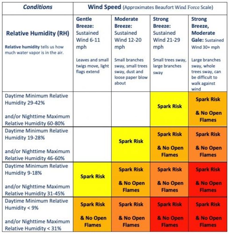
1- Critical Weather Patterns - Wind Speed and Humidity - Leading to Wildfires

If we are in the Orange or Red Zones ( see the chart) we recommend NO wood or charcoal fire burning. Covered propane grills are OK.

The Critical Weather Patterns Matrix assumes daytime 10-hour fuel moisture < 6% (measured at 1300), annual grasses are cured, and no wetting rain (greater than 0.10 inch) has fallen in the last 24 hours. The wind event should be expected to last at least 8 hours.

Spark Risk - SR:

  • Power tools are not advised: e.g. any lawnmowers, chain saws, metal blade weed trimmers.
  • Do not drive or park any vehicle on dry vegetation.
  • Double-check that trailer chains are not dragging.
  • Check on any recent burn piles or campfires that may not be fully extinguished. Always follow the "drown, stir, and feel" method.
  • For information on Campfire Safety CLICK HERE.
  • For more campfire tips CLICK HERE.

No Open Flame - NOF:

  • Wood or charcoal-fired burning is not advised. Covered propane grills are ok.


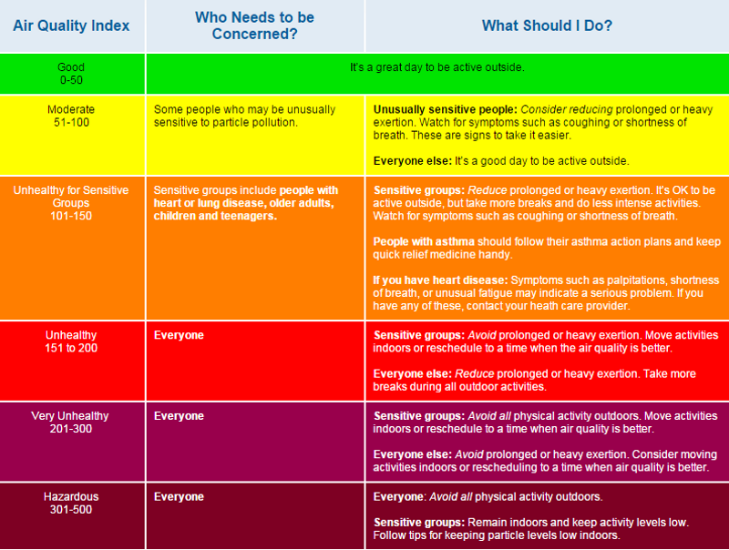
2- Air Quality Index (AQI)

If we are in the Orange, Red, Purple, or Maroon colors we recommend NO wood or charcoal fire burning. Covered propane grills are OK.

Note: In the Coloma Lotus Valley, we have Air Inversions - a layer of cooler air is trapped near the ground by a layer of warm air above the surface. When the air cannot rise, pollution accumulates near the ground, leading to higher pollutant concentrations.

Below are some links to additional resources.

AirNow and AQI Basics

EPA - Patient Exposure and Air Quality Index

Epa - Indoor Air Filtration Factsheet


Frequently Asked Questions

Where is the local data coming from?

The data that determines fire ignition risk and pollution risk is collected by different types of stations.

  • The local weather station that meets Nation Weather Service (NWS) National Oceanic and Atmospheric Administration (NOAA) standards is located off Highway 49 near Mother Lode campground. Its data can be directly seen HERE. This station provides the humidity, temperature, and wind speed data that is used to assess ignition risk.
  • The data that determines particulate matter pollution from smoke can be assessed using Purple Air sensors when their output is set to EPA standards. Here is a local Purple Air Map where the location of individual sensors can be seen. Clicking on any local sensor will give you access to particulate matter graphs spanning several days, which also indicates the degree of health risk associated with smoke particles. Be sure to select the "US EPA" conversion. The PM 2.5 AQI is an important measurement of human health. Clicking on additional Purple Air stations will overlay their results onto the graph, which enables you to see the difference between one location and another.
  • More Purple Air sensors will be installed shortly, pursuant to the Coloma Lotus Advisory Committee's (CLAC) effort to secure additional sensors from AQMD.

Is this Program for businesses or for residents?

  • It's for everyone. Sparks and embers don't care what the zoning of your parcel is - they will ignite either one. Smoke pollution is an equal consideration for local residents as well as visitors.

Is this a law or an ordinance?

  • It is neither. Many residents and businesses have expressed interest in working towards some sort of regulatory or county ordinance approach. CLAC is collecting data and community input to assess the value and impact of the program.

What laws, ordinances, and regulations are already in place for fires and smoke?

  • The County's campfire ordinance code can be found HERE
  • Campfire Tips are summarized in CalFire's publication HERE
  • Sate campfire permit information may be accessed HERE
  • BLM fire restrictions order, effective from April 2020 through 2025 are HERE
  • El Dorado National Forest maintains a current conditions page on its website that indicates where and if campfires are allowed find it HERE.

Similarly, there are many existing restrictions on smoke and particulate matter pollution at the county, regional, state, and federal levels.

  • The county adheres to AQMD regional and states Air Resources Board Open Burning rules which can be found HERE
  • Note while there is an exemption for recreational burning, compliance with Smoke Management Rules in section 300.3(F) is still required. This includes section 300.3F(1)(e) which stipulates that "Burning shall be curtailed when smoke drifting onto a nearby populated area becomes a public nuisance."
  • "Nuisance" is defined in section 300.2(P), which specifies that Health and Safety Code Section 41700 shall apply.
  • Health and Safety Code Section 41700 states that: quantities of air contaminants or other material that cause injury, detriment, nuisance, or annoyance to any considerable number of persons or to the public, or that endanger the comfort, repose, health, or safety of any of those persons or the public, or that cause, or have a natural tendency to cause, injury or damage to business or property." Click HERE for the code section.

Can I install a Purple Air (an air pollution monitor) or NOAA?NWS - compliant weather station on my property?

  • Anyone can purchase and install a Purple Air sensor - more info HERE. You will need a good internet connection and a power source to plug in the sensor outside. We strongly recommend that you test a variety of locations at your site to avoid contaminants that would only be measurable from your own property, such as fireplace smoke or barbeques, etc.
  • For an NOAA/NWS-compliant weather station, the short answer is maybe. The NOAA has a Cooperative Observer Program and there are strict siting requirements for these stations, some of which will make it difficult to install a compliant station in many parts of the Colom Lotus Valley. For more information click HERE.

Will there be fire risk signage for visitors?

  • One of the major goals of the program is to advise visitors that the Coloma Lotus Valley takes fire and air pollution risks seriously, so let CLAC know if you would like to volunteer to maintain fire risk signage during the fire season.

What do I do if I want to report a Public Nuisance - concerns about fires and/or air pollution?

  • "Burning shall be curtailed when smoke drifting onto a nearby populated area becomes a public nuisance." (see 4b above) If you feel there is a risk, please speak with your neighbor first. If you want to report it you can go to the following website (click HERE) or call during regular hours (530) 621-7501 or after hours (530) 957-3466 or call the County non-emergency dispatch line at (530) 621-6600. If calling the dispatch center, ask the dispatcher to contact the Air Quality Management District staff.

Where can I provide input on the program?

  • You can go to the contact form on this website and submit your input to us. Please put "RE: Fire safety" at the top of your message. Click HERE to go to the contact us page.